Senza categoria
Muon: Tomography for large industrial equipment.
Muon Systems creates hardware and software tools for muography applications such as border security, mining, and civil engineering. Their project aims to validate the use of muography by simulating the […]
IMPROVING BETTAIR MAPS
The experiment aims to train AI Generative Adversarial Networks to mimic the output of HPC-CFD simulations at an affordable cost, adding them to Bettair’s map generation pipeline, to better understand […]
GEMINI: High Fidelity Modeling for Small Wind Turbine
FEAC will take advantage of the HPC infrastructure to predict the aerodynamic performance of wind turbines and provide accurate results in a reduced time. Based on EUNICE’s needs, the development […]
Digital-twin for airflow and drug delivery in human airways
The experiment aims to reduce time scales and costs by generating a Digital-twin of the human airway, allowing real-time simulations of airflow and drug delivery processes. This involves a parametric […]
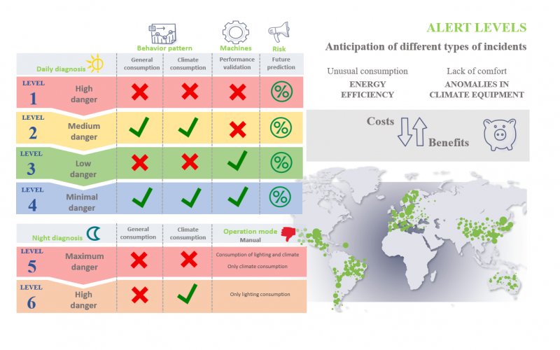
Improvement of the remote expert system based on software OTEA
Heating and cooling contribute to half of the EU’s energy demand. To meet climate goals, the sector must reduce energy consumption. Machine Learning models and statistical techniques can help manage […]
HPC Cloud-based seakeeping design
The objective of this experiment is to develop an HPC-Cloud service for seakeeping assessment for the end-users WAVEC and VICUSDT.
Optimised cutting and bending of steel reinforcement bars using Cloud-based HPC
Schnell Software offers specialized CAD-CAM software for steel cutting and bending companies, enhancing productivity and efficiency. Despite existing PC-based optimization software, it requires hours for optimal results, that are not […]
Cloud-based map interpolation for civil engineering
Sisener Ingenieros is an engineering company specializing in renewable energy projects. This projects need accurate topographical information not only to determine the earthworks to be performed, which depends on intrinsic […]